The annual Richmond Draw-Off is at an end for this year, and it’s been a spectacular one. The perfect note on which to end my final blog of 2025. It’s given me some fabulous finds, one in particular was very special, and allows me the indulgence of musing about lost and found jewels.
I’ve blogged about the Draw-Off before but, for those unfamiliar with it, it’s that time of year when the Port of London Authority (PLA) open Richmond Lock and Weir in order to carry out vital repairs. This results in some excellent low tides where, on occasion, it can look as though someone has pulled the plug on the Thames. This year’s Draw-Off has been longer than usual, beginning on Monday October 27th and ending on Friday 19th December.
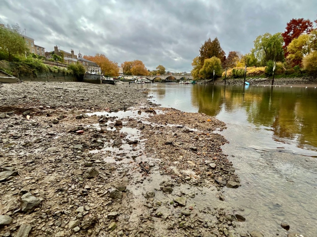
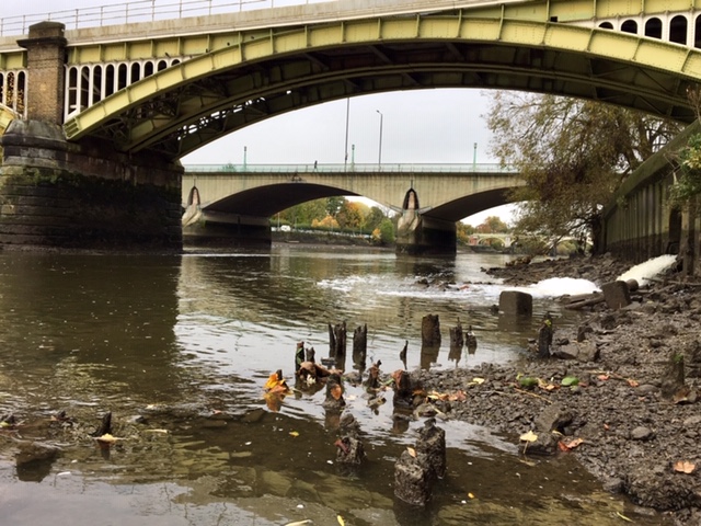
The photo below, taken this year on the first day of the Draw-Off, Monday 27th October, gives a real sense of how low the tide has been and how much of the foreshore was tantalisingly visible, making the prospect of finds very intriguing. The foreshore here is hidden for the rest of the year so it’s a very special feeling to be able to step down ancient (and rather slippery) river stairs and search for artefacts.
Richmond Riverside during the 2025 Draw-Off. The foreshore visible here is under water for the rest of the year.
For those readers unfamiliar with this part of South West London, the London Borough of Richmond-upon-Thames is well worth visiting for its green spaces (home to Richmond Park, London’s largest deer park), scenic riverside walks and rich history. It’s the home of the long lost Richmond Palace, a stunning Tudor royal residence rebuilt and renamed by Henry VII in 1497-1501 on the site of the old Shene Palace, partially destroyed by a distraught Richard II in 1395 after the death of his wife Anne of Bohemia.
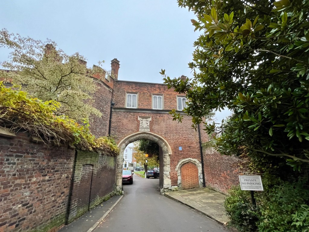
Only The Gatehouse and parts of The Wardrobe remain of the palace, though there is also surviving archaeology on the Thames Foreshore in the form of timbers from a jetty, carbon-dated to the late Tudor/early Stuart period. (Both The Gatehouse and jetty timbers are pictured below.) We also have surviving household accounts from Elizabeth I’s time here. Richmond Palace was thought to be one of her favourite homes and where she died on 24th March 1603. The Queen particularly enjoyed spending Christmas at Richmond, entertained by William Shakespeare’s acting company, the Lord Chamberlain’s Men, who performed for her and favoured members of the Royal Court.
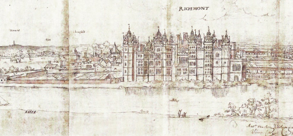
Sadly, contemporary images of the Tudor Richmond Palace are few and far between. The best visual view we have is Antonis Van der Wyngaerde’s sketch from 1562 showing its magnificent riverfront, complete with pepperpot turrets and gardens, drawn from the north (Middlesex) side of the river at what is now St Margaret’s. After Charles I’s execution in 1649, Oliver Cromwell ordered Parliament to assess the cost of demolishing the buildings and it was sold for £13,000, the stones re-used elsewhere. Eventually returned to Charles II following the Restoration of the Monarchy in 1660, by then the cost of rebuilding was too great and what remained of the ruined Richmond Palace was left to fall apart.
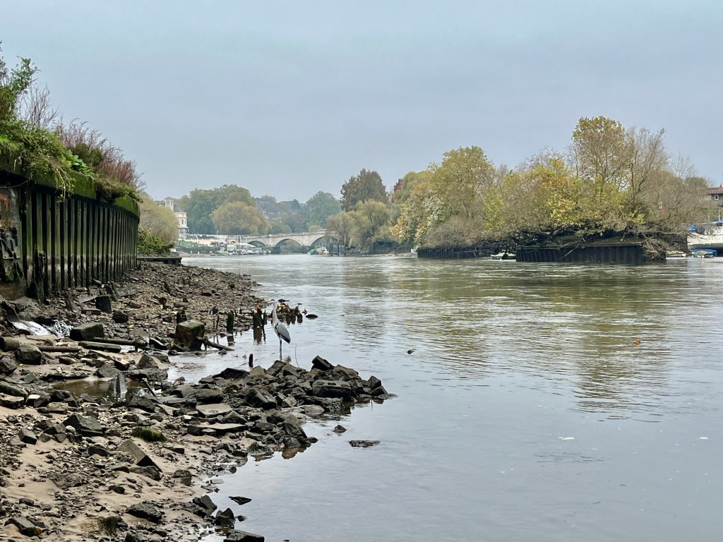
A Thames Heron faces the spot where there are still visible traces of the old Tudor/Stuart jetty. In Tudor times, Herons were hunted and eaten at Royal feasts.
The Gatehouse, one of the few surviving buildings of the Tudor Richmond Palace. It can be accessed via Richmond Green nearby, once used for sport, jousting and other Royal entertainments.
Sketch of the Tudor Richmond Palace riverfront by Antonis Van der Wyngaerde, c. 1562.
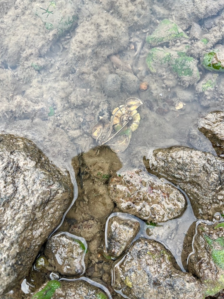
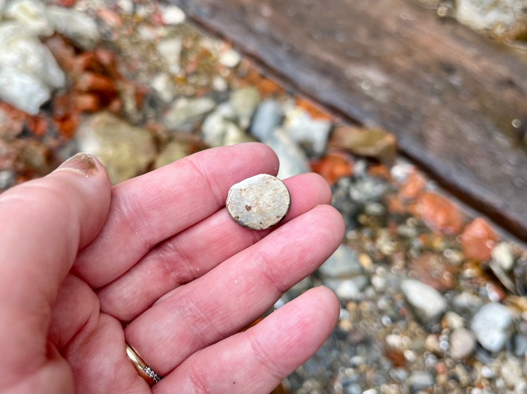
It was in the vicinity of the Tudor/Stuart jetty that I spotted one of the prettiest artefacts I’ve ever discovered on the Thames Foreshore. I’ve never found anything quite like this and it opened the door to a story that began in Central Europe in 1845 before somehow ending up in the river at genteel Richmond when I spotted a glint of something gold and tantalising in the water during this year’s Draw-Off.
Tantalising first view of something gold and glittering in the River Thames.
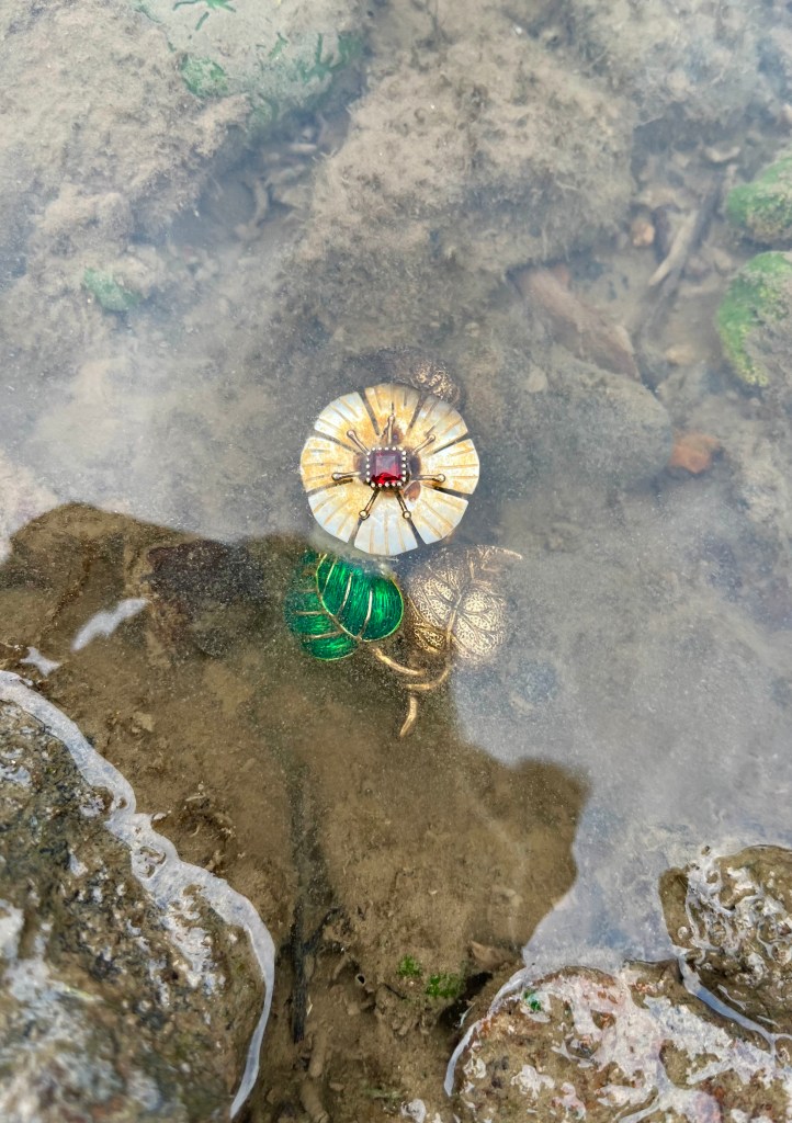
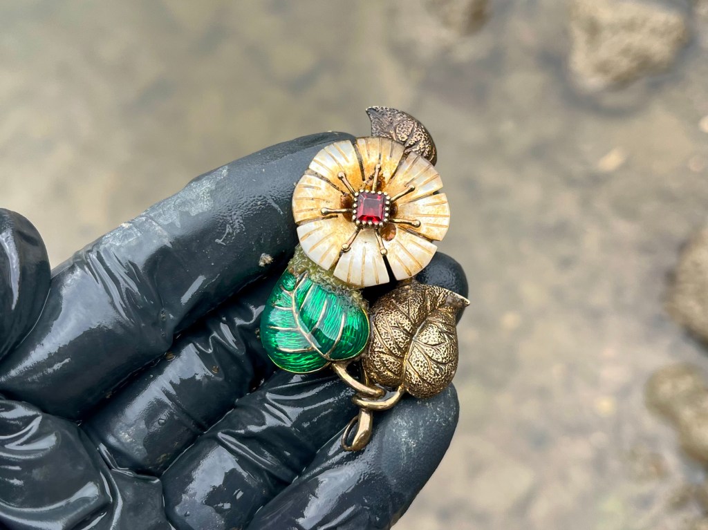
Turning it over in the water and seeing this beautiful jewel for the first time since it was lost in the river.
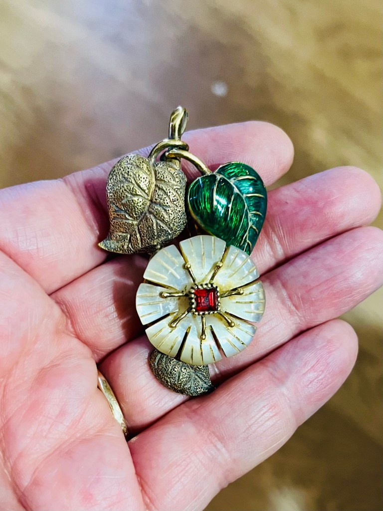
I knew I’d found something interesting and unexpected but wasn’t sure, at that stage, exactly what. A brooch of some sort, obviously, but clearly beautifully made to a very high standard using what appeared to me to be precious metals and semi-precious stones. It was also complete and undamaged, with a pin at the back. Taking it out of the river I gently removed a number of freshwater shrimps who’d made this their home over the decades, and re-housed them elsewhere in the water. There was quite a bit of mud in the nooks and crevices at the back of the brooch indicating this had been in the Thames for some time.
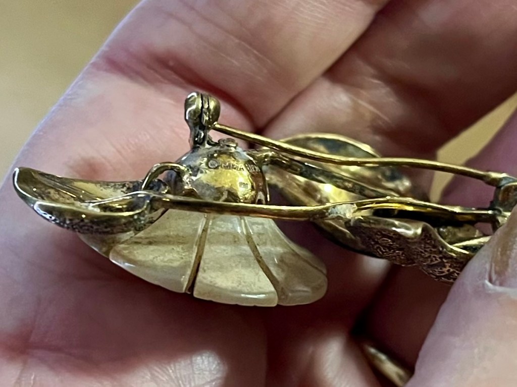
After a gentle clean-up at home, research into the brooch began in earnest. My trusty magnifying glass revealed a series of hallmarks – 925 UPM MMA – the 925 indicating gold-plated sterling silver. The other materials were mother of pearl, green enamel and garnet. Further research revealed that UPM stood for The Museum of Decorative Arts in Prague, and MMA for the Metropolitan Museum of Art in New York. This was very exciting and I immediately emailed the museum in Prague to see if they could help shed more light on the jewel.
My brooch cleaned up and showing the rear view, hallmark 925 and the initials UPM and MMA.
Another view of my brooch from the back.
I was immensely grateful to the prompt reply from the team at The Museum of Decorative Arts in Prague who were extremely helpful and were able to provide me with information that helped colour in the backstory of my Thames find. I am particularly grateful to Dr Lucie Vlčková, who I contacted first and then signposted me to Dr Petja Matějovič, who provided so much helpful detail. I’m also grateful to Veronika Mědílková who, for the purposes of this blog, organised permission for me to use the museum’s images of the original necklace my found brooch was reproduced from.
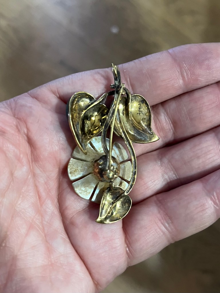
Front view of the brooch, before clean-up, showing gilded leaves, mother of pearl flower, garnet stone and green enamel leaf.
The brooch, after clean-up, showing a visible loop at the top where it would have been attached to the other parts of a necklace.
In 2000, the Museum of Decorative Arts in Prague collaborated with the Metropolitan Museum of Art in New York, allowing MMA to reproduce a limited edition collection of copies of approved artefacts. The reproductions, if this brooch is anything to go by, were beautifully made and used semi-precious materials. My find from the Thames at Richmond is one of these reproduced items.
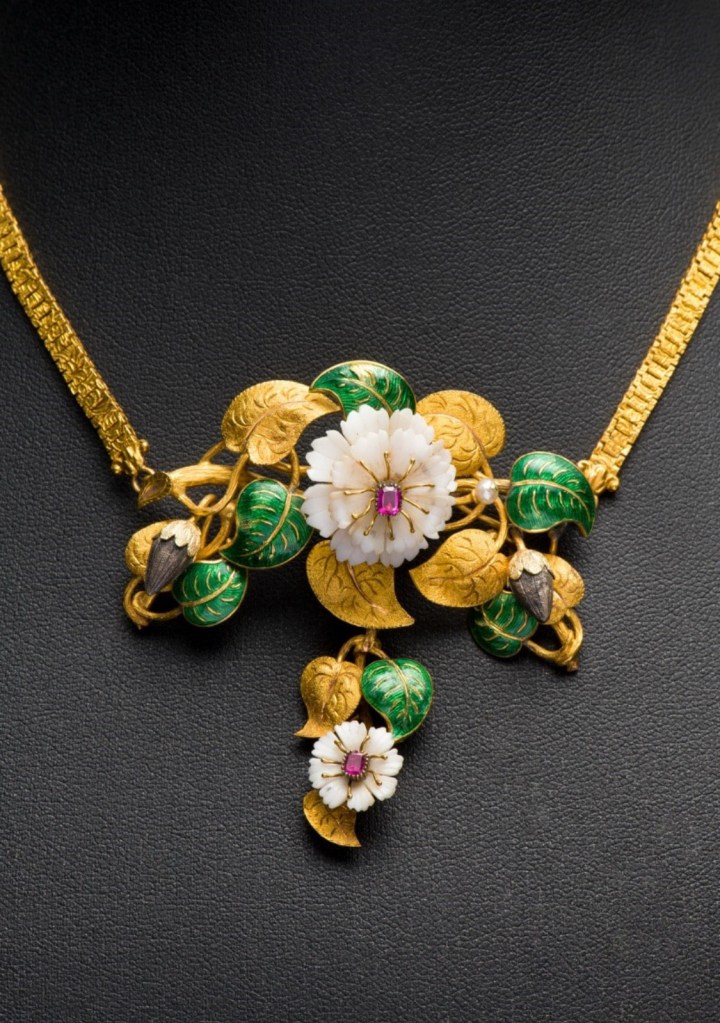
Dr Matějovič kindly sent me images from the original necklace that my brooch was reproduced from. The original necklace is now part of the collection of the Museum of Decorative Arts in Prague and was originally made in Central Europe c 1845. This necklace was fashioned from gold, silver, ivory, pearl, enamel and rubies. Common to this style, parts could be separated and worn as a brooch. It would have been commissioned for a high status and wealthy woman.
The original necklace, like so many beautiful things, would have been vulnerable during the Nazi occupation of Europe. It’s thought that it remained in private ownership and was eventually confiscated by Czech authorities after 1945 before transferring to the UPM in Prague in 1961. It has been on display here as part of an exhibition called ‘ART, LIFE.’ Dr Matějovič describes the necklace as a time capsule, symbolic of several stages of the life cycle of a plant. You can see this clearly in the way golden tendrils weave together the gold and enamel leaves, bejewelled flowers and seed pods.
The necklace also features in Dr Matějovič’s book ‘Jewellery -Form-Content’, bringing together jewellery past and present: jewellery still worn today, and jewellery that has not survived.
‘Jewellery -Form-Content’ by Petra Matějovič.
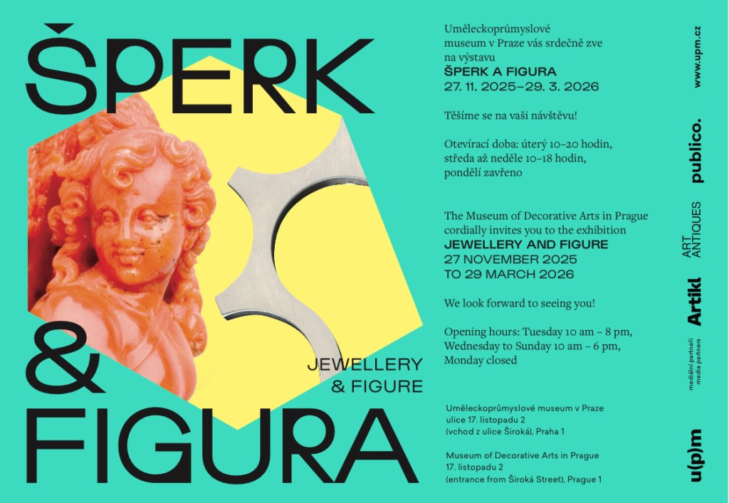
I have kindly been invited by Dr Matějovič to visit the Decorative Museum of Arts in Prague for their new exhibition ‘Jewellery and Figure’, which will be open until 29th March 2026, and hope to make the trip to Czechia sometime in the new year. A great start to 2026 and a wonderful experience to look forward to. I have included a link to the museum for more information about location and opening times:
Poster advertising the new exhibition – ‘Jewellery and Figure’ – currently on at UPM, the Decorative Museum of Arts in Prague, until 29th March 2026.
Finally, thank you to Angela (@up_for_a_lark on Instagram, please give her a follow) who was with me when I found this stunning brooch and was able to share the moment of discovery with me.
As the tide began to come back in and I set off for home I couldn’t help thinking that Elizabeth I would have approved of this find, made within the vicinity of her long lost Tudor Palace, albeit separated by a span of over four hundred years since she last spent time here. I’ll never know how this artefact got into the river, one can only speculate; it was lost, then found again. This is what mudlarks do – we find lost things and bring them and their stories into the light again.
View of the Tudor/Stuart jetty with Richmond Railway Bridge and Twickenham Road Bridge visible downstream.
The timbers of the Tudor/Stuart jetty where I found my brooch, are heavily symbolic regarding other historic jewellery. As mentioned above, Richmond Palace was reputed to be the favourite home of Elizabeth I and the place where she died on 24th March 1603.
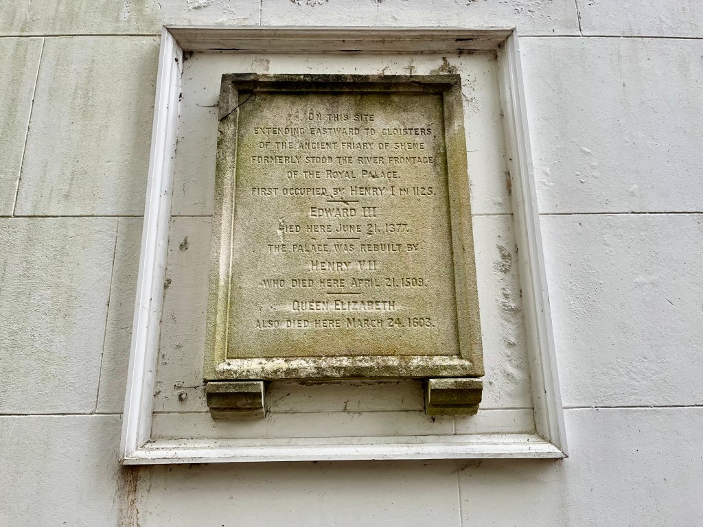
Stone monument showing details of the monarchs who lived and died at Richmond Palace, including Elizabeth 1, who died here on 24th March 1603.
When mudlarking near the jetty I often think of the moment of the Queen’s death. According to legend, Robert Carey is said to have taken the Queen’s ring from her finger after she was pronounced dead. He then rushed to a boat, perhaps tethered at this very spot (travelling by road at that time was considered dangerous, the river was viewed as a much safer option) before being rowed down the Thames into the centre of London. He then disembarked and galloped at speed on horseback to James VI of Scotland, now James I of England. Elizabeth had died unmarried and childless, so James was named as her rightful heir (his credentials as the next Monarch were that he was the son of Mary, Queen of Scots, Elizabeth’s cousin, and was also a great-great-grandson of King Henry VII.)
But as so often in history, fact is mixed with a heavy dose of fiction and exaggeration. Carey did indeed make the dash to Holyrood House in Scotland but, as far as I’ve been able to ascertain, documents show that the ring Carey was said to have presented to James was not from the deceased Queen’s finger. Historians of this period, particularly the jewellery experts, believe it far more likely that Carey handed over a sapphire ring (definitely not the Queen’s actual ring) with the words that it had come ‘from a faire lady.’ James had previously given this ring to Carey’s sister, with instructions that it should be returned after the Queen’s death. In returning the sapphire ring so quickly to the new King of England, Carey may have hoped to curry favour with him by giving him assurance that Queen Elizabeth had indeed died. He had rushed north to Scotland without any other official documentation and against the express orders of Eizabeth’s Privy Councillors, an unwise move and which made him unpopular.
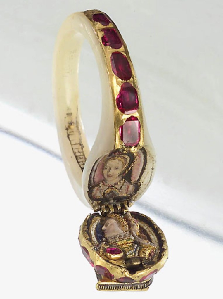
The ring that was actually taken from Elizabeth’s finger a week before her death, on the advice of her physicians, is known as the Chequers ring, and is one of the few surviving pieces of jewellery worn by her. The exact circumstances of her death are still a subject of hot debate today. Blood poisoning is commonly cited as the main reason – the Queen was a heavy user of lead-based makeup known as ‘Venetian Ceruse’, or ‘Venetian White’, which was later classified as a poison. She may also have died of pneumonia, streptococcus or even cancer. Permission for a post mortem was refused, probably to protect the cult status of the Queen’s ostensible virginity – in life she had been portrayed as a virgin, a goddess, but never as a normal woman. It was important that this myth was maintained.
Thought to have been given to her in 1575, and worn every day, the Queen’s ring had grown into her flesh over the years causing her considerable discomfort and necessitating its removal prior to her death. The Chequers ring was made from gold, mother-of-pearl, rubies, diamonds. Its chief feature is a locket with two portraits. One is of Elizabeth herself, the other traditionally thought to be her beloved mother Anne Boleyn.
Much of Elizabeth I’s jewellery has long since been lost, dispersed by James I after the Queen’s death, nor is it clear what happened to Carey’s sapphire ring either. Quite likely also lost or given away, no one knows where. The Chequers ring is uniquely special in that it survives, probably bought by the Home family, and descended down the line until acquired by Arthur Lee, First Viscount Lee of Fareham, owner of Chequers country house, which was eventually presented to the nation becoming the country home of the prime minister. The ring remains within the private Chequers collection, and is not on public view.
Jewels. Lost and Found in the Thames. And those that survive historic events to tell their tale.
And it’s on that bejewelled note that I hope you’ve all enjoyed a Happy Christmas; wishing you a peaceful and healthy New Year 2026. Thank you to everyone for reading and supporting my mudlarking blog, and for all the kind emails you’ve sent me this year.
NB Please note that a valid permit is required from the Port of London Authority (PLA) in order to mudlark or detect on the Thames Foreshore.
So Shakespeare tells us in Sonnet 18. And he’s correct. As we rattle on to the end of August, September is peeking cheekily round the corner and our parched and dry summer is coming to an end for this year. Tidying up in my garden, there’s already a sense of autumn, blackberries hanging off branches, leaves turning golden and falling from trees earlier than usual (though this is almost certainly due to the lack of rain) and the faintest sense and scent of smokiness in the evening air. It’ll soon be time to start digging out the jumpers to wear on crisp early morning mudlarking trips.
I’ve been holidaying in Roman Provence this July. Ok, I know other people’s holiday snaps and anecdotes are tedious but please bear with. My jaunt to the south of France has a purpose and is a glorious link to a recent mudlarking find on the Thames Foreshore. All will be revealed as you read on.
Incomplete Roman bone gaming counter found by me on the Thames Foreshore
Obverse of my incomplete Roman bone gaming counter
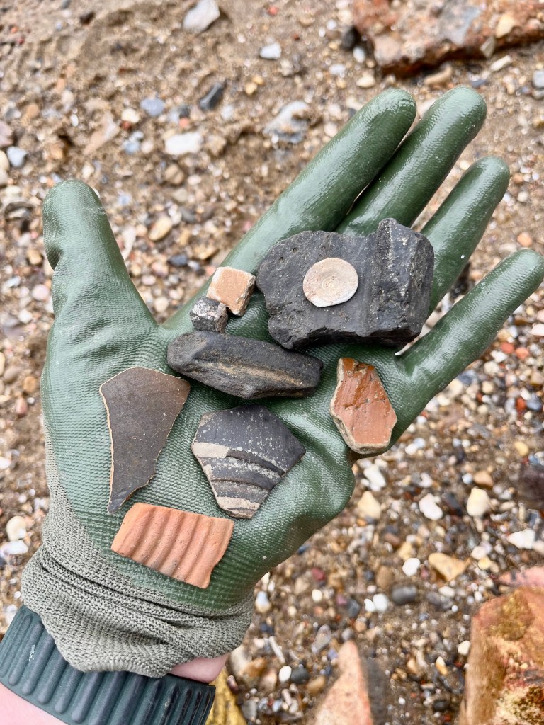
I’ve spotted Roman finds at various Thames Foreshore locations, not just in one particular area that’s known for its Roman artefacts. Without a shadow of a doubt far fewer finds are made here these days, as in most areas on the river, and yet there are always interesting discoveries waiting to be made.
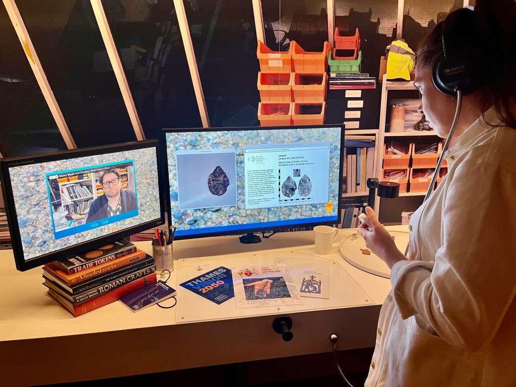
A few months ago I found something white and round lodged between two rocks and an ancient piece of timber. Thinking it was a piece of shell I nearly didn’t pick it up, but of course I picked it up. Rule number one in the Mudlarking Rule book – always ALWAYS pick things up; turn them over in your hand, weigh them, feel them, look at them properly. If still in doubt, ask a fellow mudlark. It so happened that conveniently one of these was larking on the foreshore nearby and he confirmed it as a bone gaming counter, though an unusual one. (The fellow mudlark was called Guy – do give him a follow on Instagram @mudlarking.about ) I took the artefact to show my FLO (Finds Liaison Officer) Stuart Wyatt at the London Museum as per the requirement of every mudlarking permit holder, i.e. to report your finds regularly so that the most noteworthy can be recorded on the PAS (Portable Antiquities Scheme) database. The link is here for those who want to read more about this useful resource and fantastic archaeological database https://finds.org.uk/
And I’m thrilled to say my bone counter is now recorded on the PAS – Record ID: LON-AA4BF5 – if you wish to see the detail for yourselves.
An assortment of Roman pottery sherds, burnt tegula fragment and my bone gaming counter – all found by me on the Thames Foreshore. Similar potsherds have been discovered in graves and cremations
It’s incomplete, not as glamorous as some of the bone gaming counters found by other mudlarks on the foreshore, but as it’s the first one I’ve ever found of this type I’m more than happy with that. Dating from 50 – 410 CE, the counter itself is sub circular in plan and is undecorated except for a central concave depression and a small central hole on one side, possibly from a lathe. The edges are bevelled outwards. Similar counters can be found in the reference books and papers of Crummy (Nina Crummy, Roman small finds expert and also expert in Roman material culture.) Also known as a Kenyon type A, these were produced throughout the Roman period with little variation.
The gaming counter has been heated in a fire and turned white and distorted. Fellow mudlark and artist Ed Bucknall ( also well worth a follow on Instagram at @edjbucknall) has suggested this could indicate the gaming counter might have been part of a Roman cremation. In other words, funerary goods.
The Roman Empire was multi-cultural and allowed a surprisingly diverse number of religious beliefs, though some were initially treated with suspicion, hostility and subject to persecution, e.g Christianity. Emperor Constantine famously converted to Christianity before the Battle of Milvian Bridge in 312 CE, though he continued to patronise other religions, clearly hedging his bets in order to safeguard his soul in the afterlife ‘just in case.’ Emperor Theodosius was the one who finally made Christianity the official religion of the Roman Empire in 380 CE.
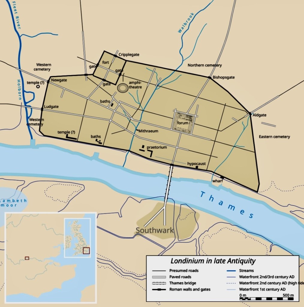
Londinium in late Antiquity showing Southwark as part of the Roman City
In Londinium as elsewhere, burial customs were adopted from all parts of the Roman Empire, adapted to suit, then later abandoned. Wealthy Roman citizens were able to commission elaborate tombs in contrast with those who were poor and whose bodies were often dumped into open pits. Burials were not permitted within the city walls and cemeteries were located away from cities, for both public health, superstitious and religious reasons, tombstones often found along main roads. Archaeological excavations of burial grounds give us a great deal of information and show a wide range of burial rites. These include conventional inhumation through to cremation and ‘bustum’, where the body was cremated over a burial pit. Many types of grave goods, including food offerings and personal objects, have been found alongside these burials. What is now the Southwark area of modern London has been the site of excavation for decades and archaeology has revealed it to have been an important place for the burial of Londinium’s dead. It was a significant area, though outside the main city walls, accessible by the first ever London Bridge built by the Romans across the River Thames.
London and the Thames looked very different two thousand years ago. The south of the river was marshy, what we now know as Southwark was essentially two large gravel islands which formed the southern bridgehead for the original (Roman) London Bridge. Major roads were built here to connect to other Roman cities in the south of England e.g. Watling Street (connecting Londinium to Canterbury) and Stane Street (connecting Londinium to Chichester.) Museum of London Archaeology (MOLA) have carried out excavations in Southwark and archaeologists have found remains of high status stone buildings together with mosaics, hypocaust heating systems and painted wall frescos.
Wooden jetties, warehouses and other remnants of waterfront activities show that the Southwark side of the river was just as much a centre of trade as the north side, and with strong links to the rest of the Roman Empire.
I was fascinated to read via the Southwark Council website that south of Borough tube station the Roman landscape was once dominated by a very large cemetery, including a number of mausoleums, walled areas containing graves and monuments to the dead lining the road along Stane Street and Watling Street. The link to more information about the history of Southwark is here:
I don’t know if my bone gaming counter came from a cremation in Southwark, but it came from somewhere and it might as well have been from Roman Southwark as anywhere else. Though there were also other cemeteries north, east and west of Londinium’s city walls.
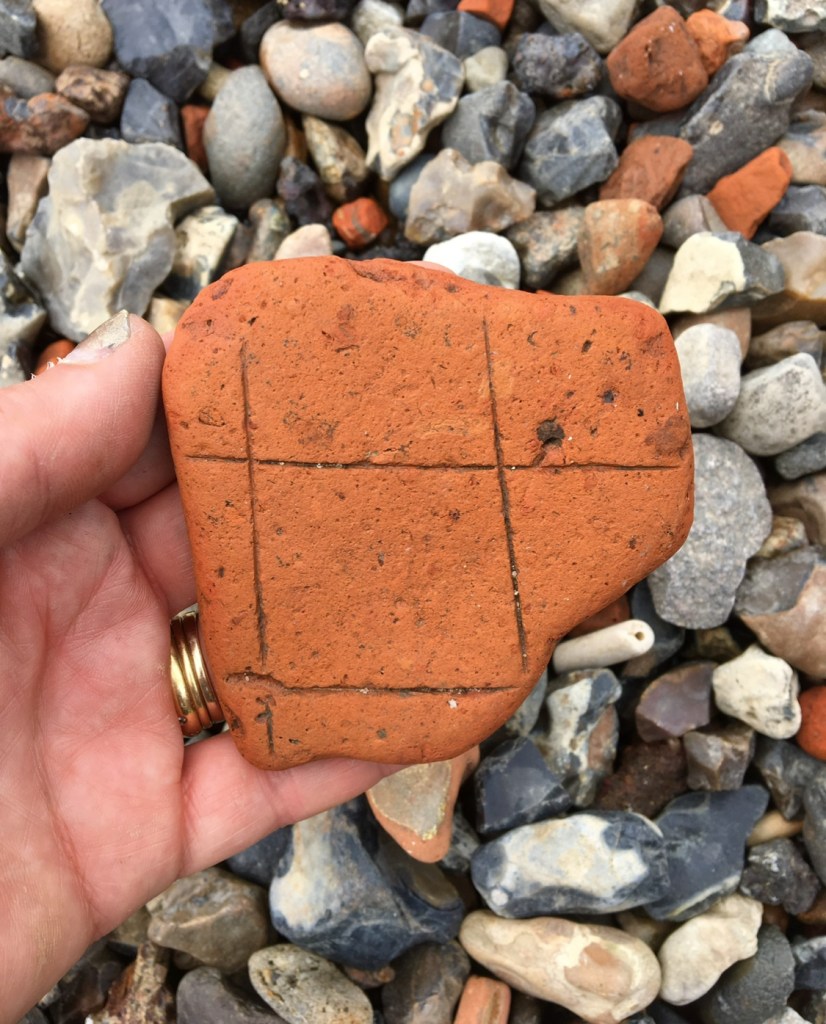
Worn section of terracotta roof tile, possibly Roman or later, showing a makeshift gaming board
The river often plays games with us and coincidentally I found a worn, incomplete section of terracotta roof tile near where I’d found the bone gaming counter. I like to imagine someone beavering away making tiles and laying them out to dry in a courtyard. Boredom sets in and they idly mark a square piece of spare clay into a grid. Not a fancy gaming board that a high status individual or soldier might have used for the playing of Ludus Latrunculorum (similar to chess or draughts, the winner is the player who’s captured the most pieces) but a poor man’s or woman’s gaming board – functional, portable, will do the job. Something to while away the long hours in the tile maker’s yard when the boss wasn’t looking. That said, it’s impossible to tell if this is Roman clay; it could be later, but was found in an area of foreshore where Roman artefacts are found, and it’s the rich terracotta colour of the Roman era. I’ll never know, but it’s fun to let the imagination run riot and there’s no harm in speculating. And on this note, a third favourite mudlarking Insta recommendation is Peter (aka @ _tidetravel ) who writes in a much more evocative way about his mudlarked finds than I’ve done above, and really takes you back in time with his stories and descriptions of artefacts. He’s well worth a follow.
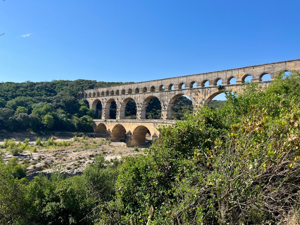
The Pont du Gard
Photo taken by my daughter, me striking a pose in front of the Pont du Gard
I am obsessed with Provence in the south of France. Mostly because of the history – Provence has some of the world’s most impressive Roman remains – but also the food and wine are rather good too. The name ‘Provence’ itself is a translation of the word ‘province’, i.e province of Rome. In Arles, Aix-en-Provence, Nîmes, Orange and Vaison-la-Romaine, you will find some of the best preserved arenas, amphitheatres, spas, villas and other monuments anywhere in the Roman world.
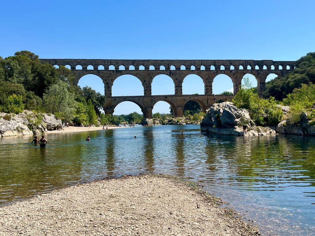
I’ve wanted to visit the Pont du Gard for my entire adult life and finally managed to do so this summer. It wasn’t hugely busy either, though we went on a scorchingly hot July day. Situated in the Gard department of Languedoc-Roussillon, 20 kilometres from Nîmes (Roman Nemausus), the Pont du Gard was an aqueduct constructed by the Romans in approximately 19BCE to 50CE as part of a system to carry water for 50 kilometres across hills and valleys to the wealthy of Nemausus for their fountains, baths, gardens and drinking water.
After the Roman Empire collapsed, the aqueduct fell into disuse. Over time the stone blocks were looted, eventually it was used as a toll bridge, then repaired and restored to the stunning monument we see today. There is also a museum, cafés and a gift shop as you enter the site (and some of the best ice cream for sale in Languedoc-Roussillon.)
Flowing through the arches of the aqueduct is the gentle river Gardon that can rise and flood and be torrential during the winter months. We swam in its waters on the hottest of hot days of our visit and it was difficult to imagine it as a viciously turbulent mass of water. Roman engineers were highly skilled and designed the foundations of the bridge in a shape like the tip of the prow of a ship, thus helping protect the aqueduct from violent currents. As we swam, and I checked the shallow river bed for artefacts (there weren’t any but it’s impossible to keep that mudlarking eye still, even when on holiday) I imagined the labourers and soldiers building the aqueduct all those millennia ago and wondering if they also played board games in their precious downtime using bone gaming counters, just like the one I found on the Thames. I’m sure they did.
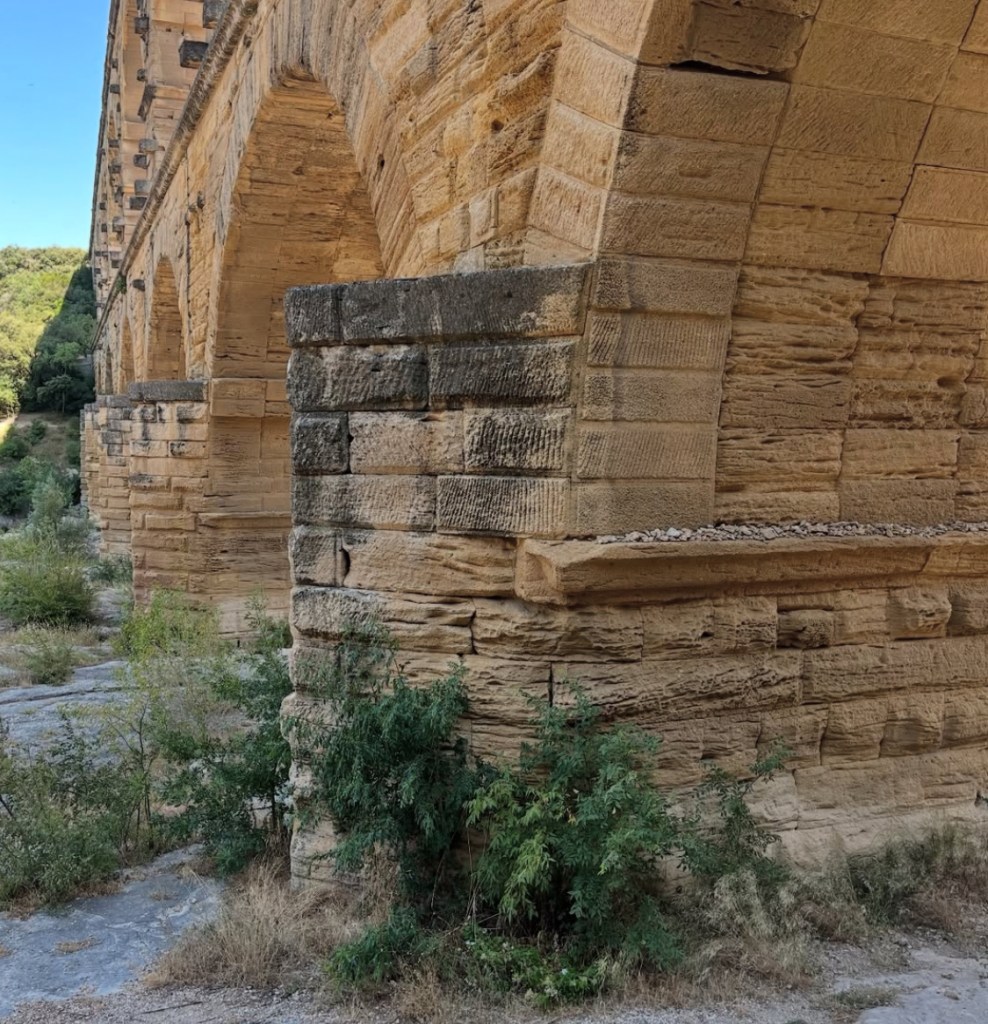
Foundation stones of the Pont du Gard, designed like the prow of a ship to withstand storms and heavy currents
The Gatekeeper of the Pont du Gard
The Gardon
Spectacular views of the Gardon from the Pont du Gard
Prior to making our way down south to Provence we stopped off in Paris for a few days to visit my two favourite museums in the capital. If you haven’t been, I highly recommend the Musée Carnavalet ( free to enter) in Le Marais and the Musée Cluny (not free to enter) in St Germain-des-Prés; both museums are closed on a Monday. If you can’t cope with the huge crowds in the Louvre or Musée d’Orsay then these two smaller museums are perfect for you. The Cluny is France’s National Museum of the Middle Ages. In the heart of the Latin Quarter, it’s an amazing collection of historical buildings comprising Gallo-Roman thermae or public baths with divine exhibits everywhere you look, many familiar to my fellow mudlarks. Gazing at the contents of the cabinets it really was like greeting old friends.
Roman Pottery from the Carnavalet
Roman artefacts from the Carnavalet
Roman artefacts from the Cluny
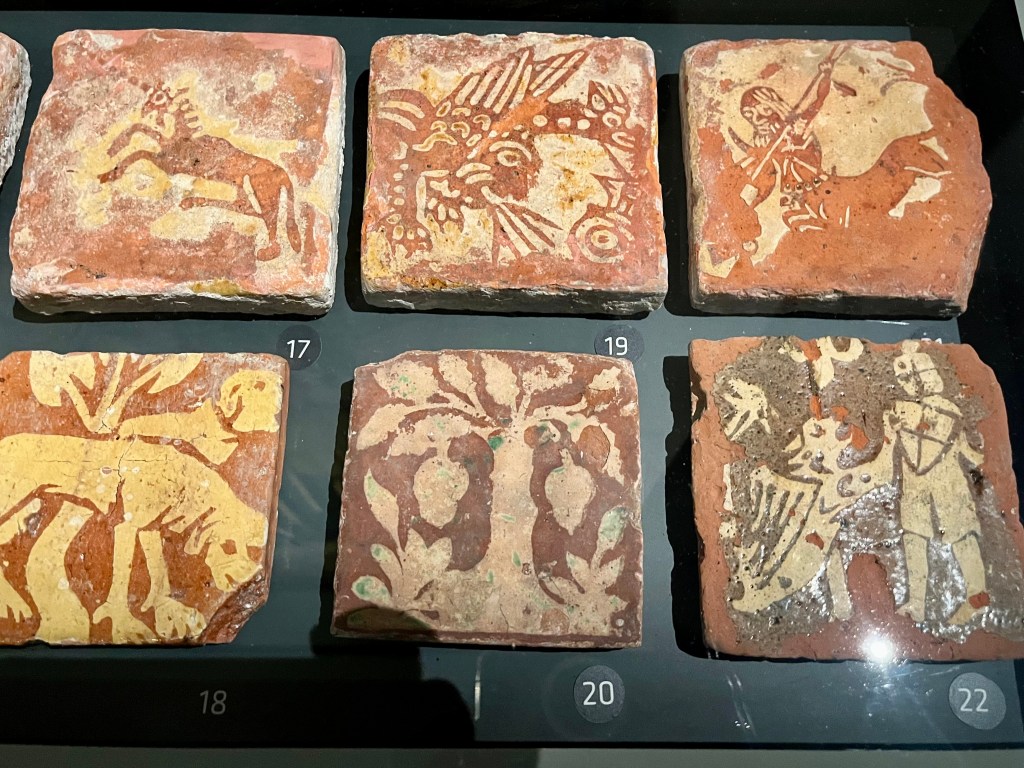
Medieval floor tiles from the Cluny
Strolling from the Carnavalet to the Cluny, where many familiar saintly friends were on display, it was comforting to see this sort of Medieval ‘Entente Cordiale’ via the medium of religious artefacts bought, and lost, by pilgrims over the centuries. Featuring St Thomas Becket, St Veronica, St Anthony, Our Lady and also many unfamiliar ones. Clearly pilgrims travelled to many different shrines across Europe and quite a few of the badges on display have not, to my knowledge, been found in the Thames e.g. St Fiacre en Brie, St Maur, St Vincent, St Léonard, St Julien of Le Mans, St Geneviève and St Corneille.
Medieval pilgrim badges and their molds, greeted like old friends
Medieval potteryfrom the Cluny
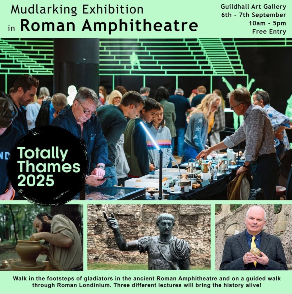
And I’m finishing this blog with a ‘save the date’ reminder. The first of our mudlarking exhibitions for Totally Thames 2025 will be taking place at the Guildhall Art Gallery in the City of London, on Saturday 6th September and Sunday 7th September (I’ll be exhibiting my finds on the 6th only.) If you’ve never visited, the Guildhall is the site of Londinium’s amphitheatre and a stunning building, the perfect setting for a mudlarking exhibition.
Totally Thames 2025 – Roman Guildhall
Lost and Found – Totally Thames 2025
The link below will take you to the complete calendar of events for Totally Thames 2025, including the fascinating ‘Lost and Found’ series of events. These feature the stories of prison hulks, ancient wharves, East African seamen who settled on the Thames and many others revealed from archives, family histories and mudlarked objects from the river. For centuries the Thames has re-shaped the city of London and its people, connecting local communities with global flows of trade, migration and ideas.
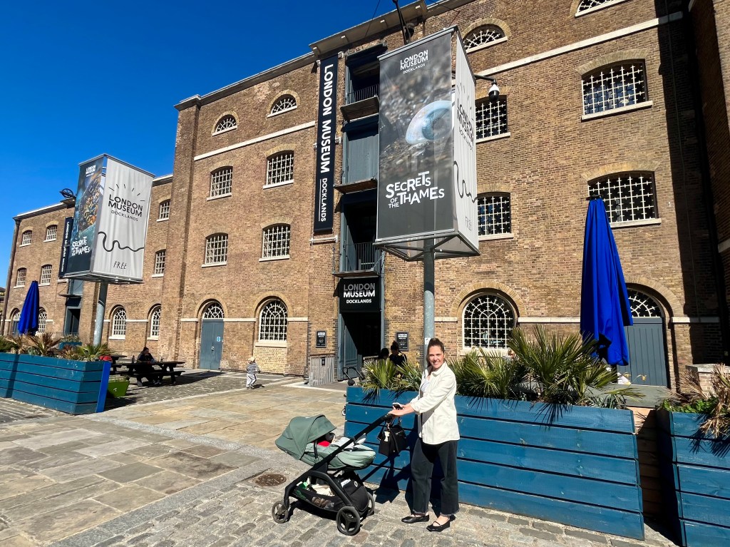
Secrets of the Thames at the London Museum, Docklands
It’s been a hectic few months on the mudlarking front, and this Easter weekend has been the first time for a while where I’ve had the space and time to sit down, draw breath and reflect. (And write this blog, of course.)
At the beginning of April I was kindly invited to a preview of a new mudlarking exhibition at The London Museum, Docklands. Along with other fellow mudlarks, friends, family and a smattering of celebrities from the worlds of history and archaeology, I was given the opportunity to mingle over wine and nibbles and enjoy my first glimpse of this long awaited event. Canary Wharf was literally buzzing that evening. So, I dressed in my best sparkly sequins and prepared for an evening of mudlarking rock’n’roll.
Fellow mudlark Fran Sibthorpe, archaeologist Raksha Dave, and yours truly raising a glass at the preview of ‘Secrets of the Thames’
‘Secrets of the Thames – Mudlarking London’s Lost Treasures’ is a unique, year long exhibition dedicated to the hidden world of mudlarks, exploring the stories behind a range of fascinating objects and finds. The preview night was brilliant and busy but I spent so much time chatting to everyone that I didn’t get to see everything properly. This necessitated a second visit the following week, this time accompanied by my daughter and baby grandson, who slept peacefully all the way through oblivious to his mudlarking granny’s modest contribution to the exhibition, but no matter. I hope I’ll be able to take him mudlarking with me one day when he’s older.
Second visit to Secrets of the Thames at London Museum, Docklands, this time with my daughter and baby grandson
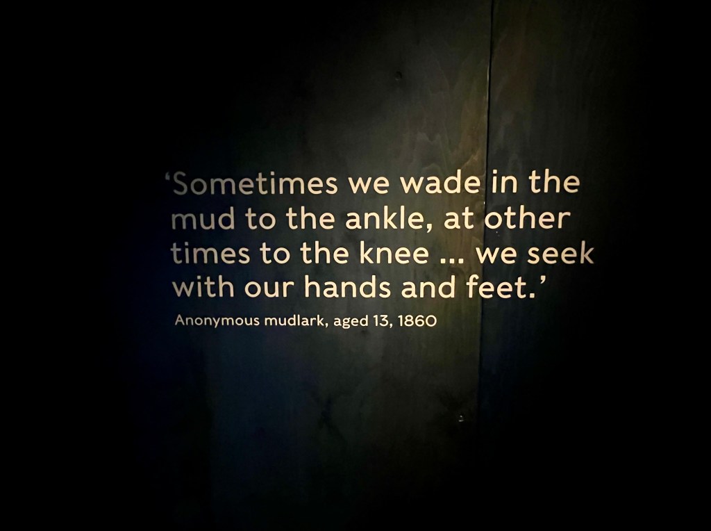
Twice a day, every day, the tide recedes. As this liquid carpet rolls back it reveals artefacts from London’s past; broken pottery, roof tiles, clay tobacco pipes, gaming pieces, a child’s shoe or maybe a tantalising glimpse of a colourful glass bead as it emerges slowly from the mud. The River Thames has served as a vibrant and bustling trade hub for millennia. A final resting place for lost souls, love affairs, the site of battles, criminal activity and executions, a repository for a range of tiny hidden treasures that mudlarks search for at low tide, just as they have done since the poor of Victorian London – the original mudlarks – tried to eke out a living by looking for items they could sell, such as coal, wood or copper.
Poignant quote from an anonymous child mudlark, aged 13, 1860
Today’s mudlarks are more fortunate and can focus on uncovering the past. We don’t mudlark for profit, indeed we are not allowed to sell the things we find. Licensed mudlarks are hobbyists, but so much more than that. We are passionate about what we do and view mudlarking as a privilege. We don’t take our permits for granted. Mudlarks have discovered thousands of artefacts that tell the story of London; its history, trade, industry, fluctuating and ever changing population, immigration, survival and regeneration. I am so grateful to be a small part of this; it’s the very heart of what the exhibition is about.
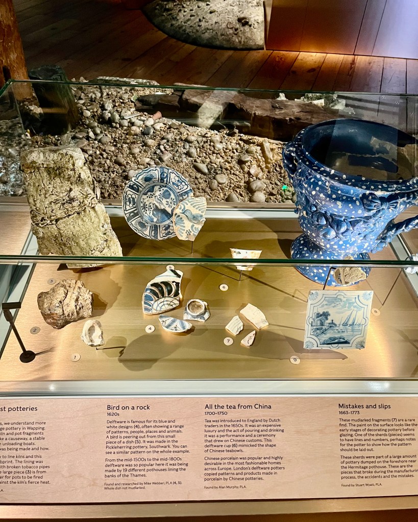
Display cabinet showing sherds from the first potteries on the Thames
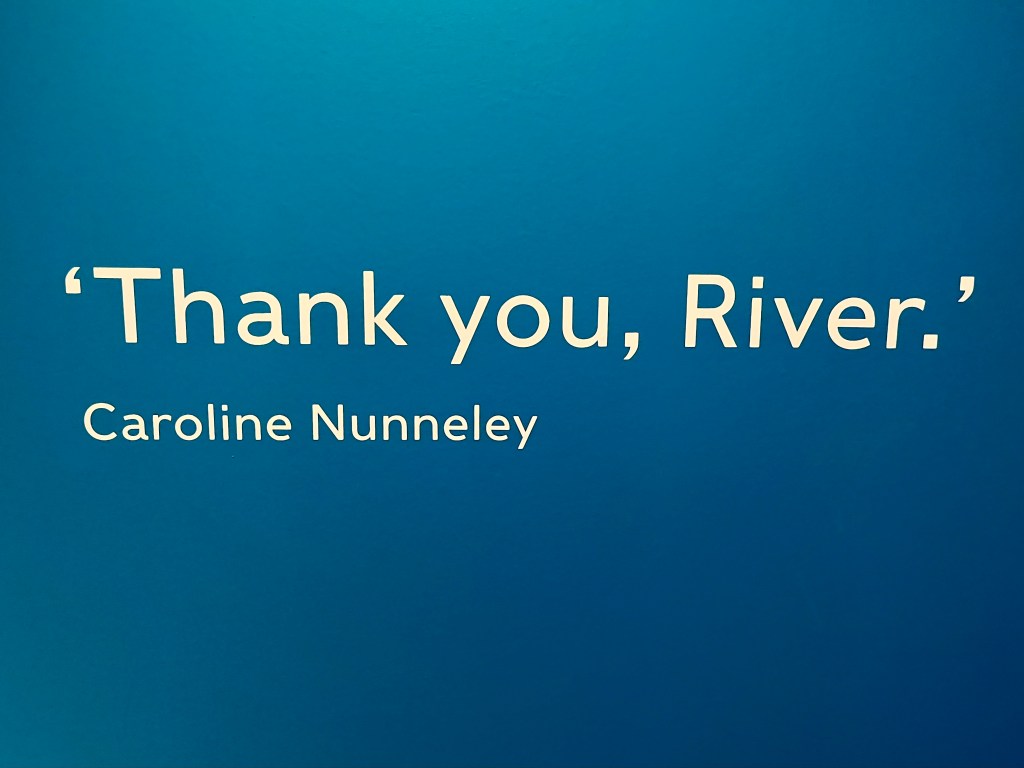
‘Secrets of the Thames’ is thoughtfully curated by Kate Sumnall and her talented team. On entering, you are welcomed by contemporary accounts of mudlarking, paintings and pamphlets providing context for the exhibition. Visitors are then encouraged to explore and engage with the displays, subdivided by period and theme. The exhibition doesn’t shrink from addressing difficult subjects, and one powerful section covers the West African slave trade, as it should. We also hear first-hand accounts from today’s mudlarks, and quotes from them are displayed throughout the exhibition as they describe what mudlarking means to them personally. This short, sweet and perfect quote by fellow mudlark Caroline Nunneley (@carolinenunneleymudlark on Insta) says it all.
‘Thank you, River’, quote by mudlark Caroline Nunneley
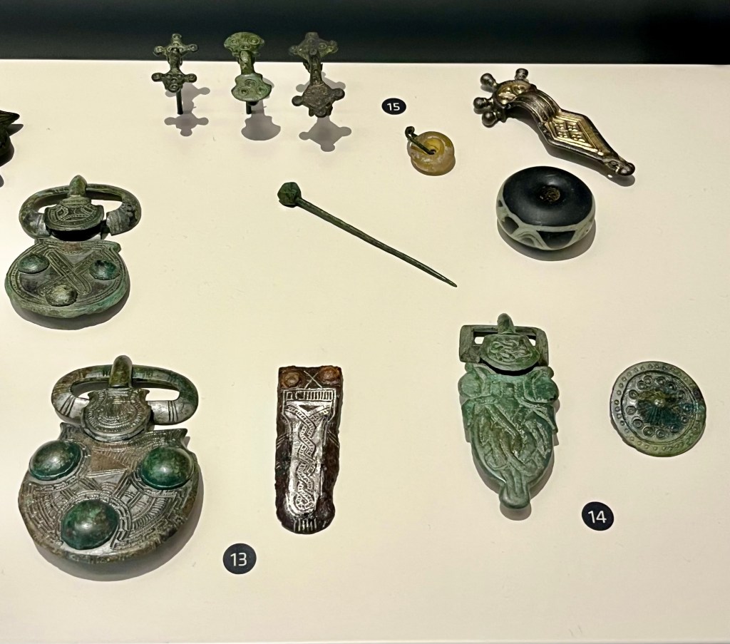
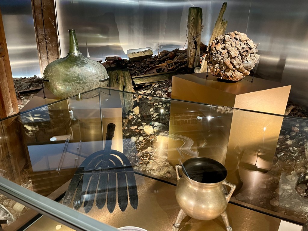
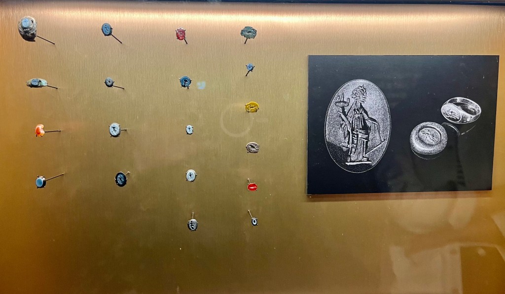
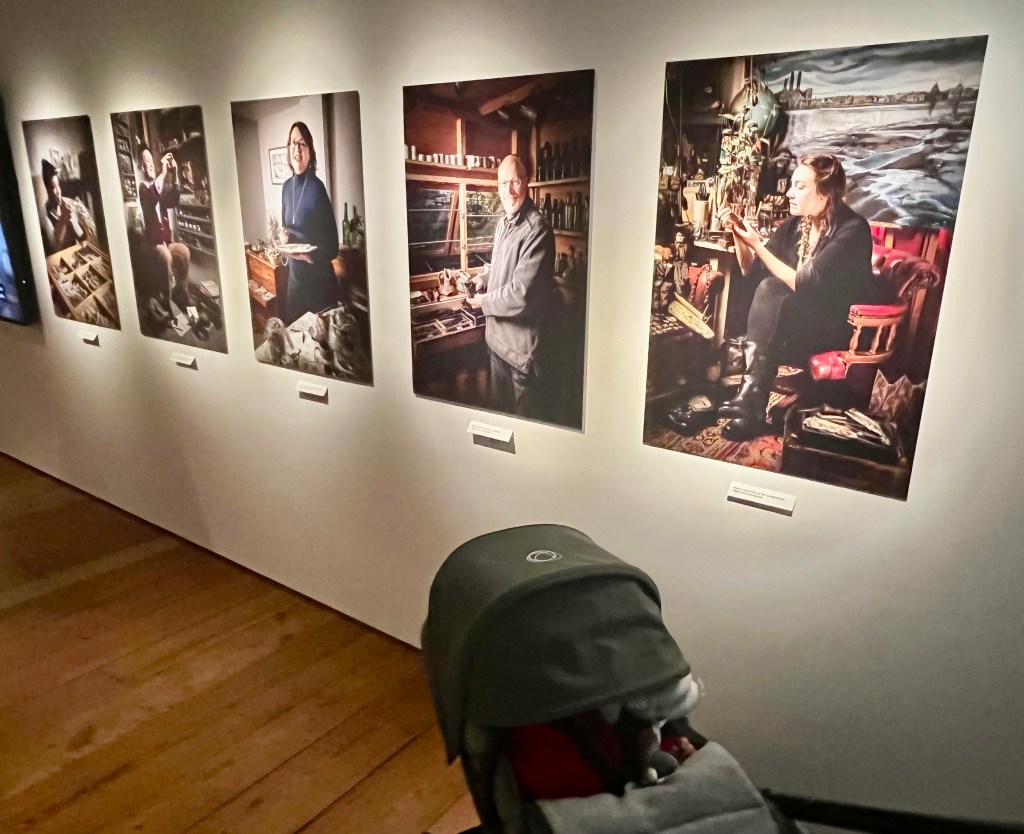
I’ve posted just a small selection of some of the artefacts on display. There were so many fascinating things to see that I’d prefer you go to check them out for yourselves. But if I had to single out some favourites (please don’t judge me) I would have to plump for the 18th century eel fork (photo below), Roman intaglios spotted by mudlarks over the years ( definitely a ‘wish list’ find for me, perhaps one day….), stunning pottery reproductions, sketches and prints by mudlarks Mark Sowden, Charlie Dixon and Ed Bucknall (@marksowden3 @charlie.collects and @edjbucknall on Insta) and mudlarking-influenced sculptures – ‘Finders Keepers’ – by Billie Bond (@billiebondsculptor) The work of some exceptionally talented people is on display here showcasing the mudlarking finds. The perfect juxtaposition of old with new. The mudlarking community is very talented and creative.
One of my favourite exhibition artefacts – an 18th century eel fork
Roman intaglios found by mudlarks on the Thames Foreshore
Mudlark Caroline Nunneley – from the ‘Finders Keepers’ series by sculptor Billie Bond
Mudlark Mark Sowden and some of his Roman Pottery reproductions, inspired by sherds found on the Thames Foreshore
A personal highlight of the exhibition for me comes as the exhibits draw to a conclusion. Utterly inspired, it’s a HUGE glowing Moon, the work of Luke Jerram and Felix Taylor. I couldn’t believe that the Moon has it’s own room. How lovely is that?
The Moon Room, created by Luke Jerram and Felix Taylor
My baby grandson and daughter silhouetted in the Moon Room
I took so many photos of this shiny silvery orb. Completely entranced. For without the Moon mudlarks are nothing. We cannot do what we do without it, because the Moon’s gravitational pull is the primary driver of earth’s tides.
On Earth, our precious oceans bulge out on both the side closest to the Moon and on the side further away from the Moon. These bulges create high tides. The low points are where low tides occur. Thank you, NASA, for the scientific explanation.
And at the New Moon or Full Moon, the tidal range is at its maximum. This is called a ‘spring tide’, when high tides are very high and low tides are very low. The phrase is nothing to do with the actual season of Spring. Rather, it means’ spring’ as in ‘spring forth’, ‘jump’, ‘rise’, ‘burst’ etc. Basically our oceans are bulging more than normal and it’s mind-blowing to contemplate.
So do say a special hello to the Moon Room when you visit.
My daughter checking out the mock-up of Stuart Wyatt’s (FLO) desk at the London Museum, a familiar sight for mudlarks who come to report their finds. This is a requirement of all who hold a mudlarking permit
But my photos aren’t doing this exhibition justice. You should go and see it for yourselves. Above all, it is rich in human experience. When I was a fresh-faced undergraduate studying for my history degree at university, the curriculum was predominantly about Kings, Queens, Politics, Treaties and Wars. Mudlarking is so much more than this. It’s about the lives of ordinary people whose names we might never know but who lived, loved, feared and hoped, just like we do now. This is what the artefacts we find bring to London’s story throughout millennia. A unique archaeological resource and rich legacy of the city and its peoples brought to life through items lost to the river over time.
My baby grandson being introduced to photos of myself and fellow mudlarks (though he slept through it all.) Photographs copyright John Chase, The London Museum
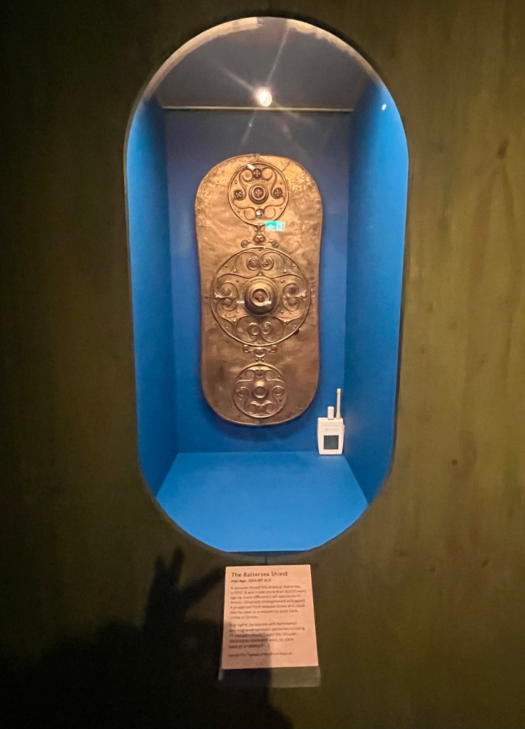
A joy to see the Battersea Shield, dredged from the Thames in 1857 during excavations for Chelsea Bridge
Last but not least, I must give a big shout-out to amazing photographer John Chase, who spent the preview evening ‘on duty’, recording the event with his camera, and for all the wonderful photos and images he’s taken for the London Museum exhibition.
John Chase busy at work photographing mudlarks Fran Sibthorpe and Jo Cook @johnchase5350 @franjoy7 and @little_jo_cook_mudlark on Insta
Secrets of the Thames is on at the London Museum, Docklands, until 1st March 2026, so there is plenty of time to book to see it. For more information and tickets click on the link below:
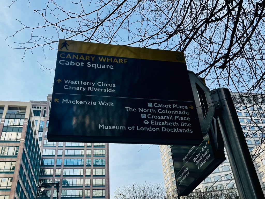
Canary Wharf with sign to the London Museum, Docklands
NB It is a legal requirement to have a valid permit from the Port of London Authority in order to search for, and remove, items from the Thames Foreshore. Further details here:
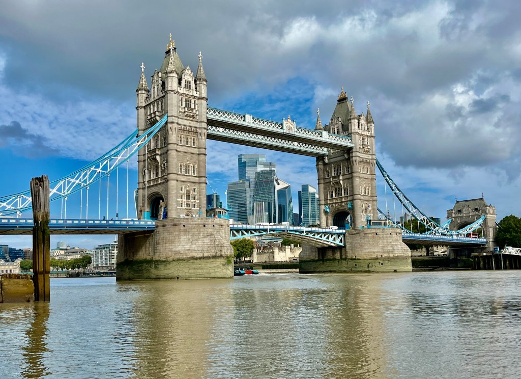
Tower Bridge, September. View from the foreshore at Horselydown Stairs looking upstream
It’s late September. Summer, or what’s passed for summer in the UK this year, is morphing slowly into autumn, students have returned to their studies and the seasons turn again.
I’ve made some wonderful mudlarking finds since my last blog – a Thames thimble, a Victorian-era halfpenny inkwell, another 15th/16th century Pinner’s bone AND my first ever Roman coin! – and life has been busy. But I’ve decided to save writing about these finds for the next blog and to write about something else this time, something very dear to my heart. The Thames Path.
‘Solvitur Ambulando’ is a phrase I learnt during Latin lessons at school. Loosely translated it means ‘it is solved by walking’. Often attributed to dear St Augustine though like so many famous sayings no one quite knows who actually said it first. But it’s long been known and championed that walking is a wonderful thing to do – good for both our physical and mental health.
All of which segues neatly into writing about The Thames Path, and I’ve spent quite a bit of time walking various stretches of it this month too.
Stretching for approximately 185 miles in total, the Thames Path follows the greatest river in the world from source to sea, past bucolic water meadows, picturesque rural villages and historical towns and cities. There are many different routes you can take, both long and short, according to taste, level of fitness and how far you want to walk. There is an excellent Thames Path/National Trail website with lot of information and advice if you’re planning a walking route:
The idea for Thames Path walks was first proposed in 1948 though they weren’t officially opened as walking routes until 1996. The route this blog is focusing on is a fairly short one, all things considered, from London Bridge to Rotherhithe, walking in a downstream (easterly) direction along the river.
Bollywood comes to the River Thames
As you exit London Bridge station, cross the road and turn right along Tooley Street, then left along More London Place. You’re never far from the river in this location and you’ll see it re-appear as you approach City Hall and Potters Field Park. Tower Bridge looms straight in front of you.
On the rather grey September morning when I walked this particular stretch of the Thames Path, Potters Field Park was a riot of colour. A group of Bollywood actors and dancers had taken over and were practising their moves, barefoot, on the grass. It was lovely to see. After a chat and some photos I waved them goodbye and walked on.
Continuing southside under Tower Bridge Shad Thames appears in front of you, The Anchor Brewhouse on your left. In 1787 Scotsman John Courage bought a small brewhouse on this very site. A year later, records state that he’d managed ‘to brew 51 barrels of beer at the Anchor Brewhouse, Horselydown’. The building was later expanded to include a boiler house and malt mill in addition to the brewery itself. The current building dates from 1871, largely rebuilt in 1894-1895. Later restoration work took place during the 1985 -1989 redevelopment of this area and the building is now Grade II listed.
The Anchor Brewhouse, Horselydown
As a side note, while writing this blog I got majorly distracted by my research into the history of brewing in Southwark, which is long and distinguished, its roots going back to the early Medieval period. The landscape then was very different with many small streams, in addition to the Thames itself, providing one of the essential ingredients for this industry – water. Both Chaucer and Shakespeare have at different times mentioned the brewers of Southwark in their writings.
Women dominated the brewing industry throughout England from about 1300-1500, after which the patriarchy essentially flexed its muscles and pushed them out. The reasons for this are both obvious and complex though, in a nutshell, men became increasingly insistent that more traditional gender roles should be adhered to by women, especially once the Reformation had swept through much of Northern and Central Europe, leaving them vulnerable to charges of ‘crimes’ such as witchcraft, with its inevitable trials and punishable by death, if they upset the status quo. It was instead preferred they should stay at home busying themselves with domesticity and raising children.
The history of medieval brewing has given me a fresh insight into women and business in the Middle Ages which, for all its difficulties, allowed them a measure of financial independence and freedom, particularly for those who were unmarried, to pursue a way of life that gave them some degree of agency. It’s unfortunate that we will never known their names because amid the chaos of life in Medieval Southwark, unlike north of the river, there was little in the way of record keeping.
It isn’t perhaps as widely known as it should be that from Ancient Egyptian times onwards the very first brewers were women. They brewed for religious ceremonies and to make a practical, protein and carbohydrate-rich drink for the home at a time when working class people could not afford wine, and river water wasn’t clean or safe enough to drink on its own. Plus ça change…
And it was women who brewed and sold most of the ale in Southwark , indeed in much of Medieval England. They produced and sold ale from home (ie ‘home’ was often just one small room shared with others), or going to market to sell their brew from cauldrons. Southwark, south side of the river, did not have the regulatory controls of the City of London and Guilds on the north side of the Thames, so women were free to produce and sell as they wished, earning money and enjoying a measure of financial independence and control thanks to their knowledge of fermentation, often passed down the female line of the family.
In fact, the word ‘Brewster’ means a female brewer. The first mention of women’s involvement in this trade in Southwark appears in about 1200. At that time brewing meant producing ‘ale’ – a drink made from fermented yeast, malted grain and water. If you had access to water you could make ale. It was sweet tasting and popular, widely consumed, but unstable and spoiled quickly. It also couldn’t, for obvious reasons, be produced in large quantities.
The introduction of hops and changes in farming practices in the 16th century precipitated widespread changes in the brewing industry, another reason why women began to be squeezed out.
Inevitably by 1600, most brewers in London were male. The use of hops in brewing switched the focus from ale to beer and made the product more bitter but also created something more resilient. Making beer conferred social prestige on the (male) brewers who had the money to invest in equipment thus beginning the industrialisation of brewing. Financially, logistically and socially women could not compete with this and it meant they were effectively pushed out of the brewing process.
So, when you look up at the Anchor Brewhouse spare a thought for the raucous playground that was medieval Southwark and pay silent homage to the women brewers who went before.
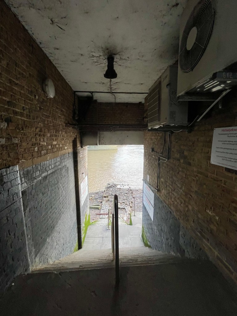
Horselydown steps leading to the foreshore
Horselydown steps. Now badly weathered, so it’s important to take great care here
There are steps that take you through the Anchor Brewhouse onto the Thames Foreshore from which there are magnificent views of Tower Bridge. The Thames Foreshore is an open public space, though with some restrictions in certain places, and you are free to walk here. But I do urge extreme caution for anyone navigating these algae-covered river steps as they are old and eroding fast. On the day I took the above photo of Horselydown stairs, a tourist had slipped and fallen down them. She was a bit shaken but fortunately wasn’t seriously injured. A young German couple got chatting to me and told me that this location is advertised quite openly on TripAdvisor (which is where they’d learnt about it) but they didn’t recall it coming with health and safety warnings. So, if you are coming down here, please be careful and wear decent footwear. Cool photos of Tower Bridge on Instagram are no fun if you’ve ended upbreaking an ankle to get them.
The Port Of London Authority (PLA) who manage the Thames Foreshore have an excellent page with advice on visiting the Thames, including a free ‘Go Jauntly’ app which is useful to download:
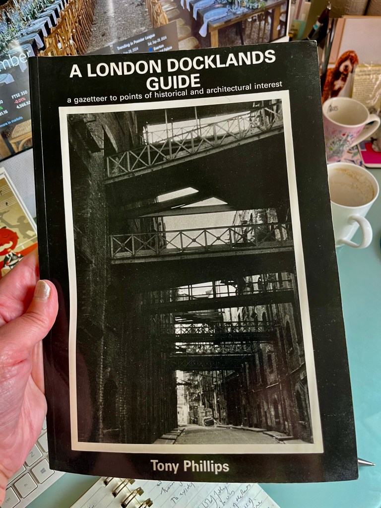
Shad Thames in the 1980s, prior to redevelopment, as seen in this London Docklands Guide by Tony Phillips
Re-emerging onto the pavement outside The Anchor Brewhouse you will find yourself back on Shad Thames, the name itself is a corruption of ‘St John at Thames.’ In the Victorian-era, when the Port of London was one of the busiest ports in the world with goods being loaded and unloaded from literally thousands of boats, barges and lighters, Shad Thames was known as the largest warehouse complex in the capital. Completed in 1873 these warehouses were home to huge quantities of coffee, tea, spices, dried fruit and all sorts of other commodities brought in from around the world. This led to the area being known as the ‘larder of London.’
Cardamom Building, Shad Thames
Today Shad Thames has been re-developed into offices, luxury apartments and restaurants. But the history of this area remains in the very bones of the buildings. As you walk along you can still see the overhead gantries which connected the warehouses and, if you stop for a moment outside Cardamom Building (pictured above), close your eyes and imagine the scent of spices in the air.
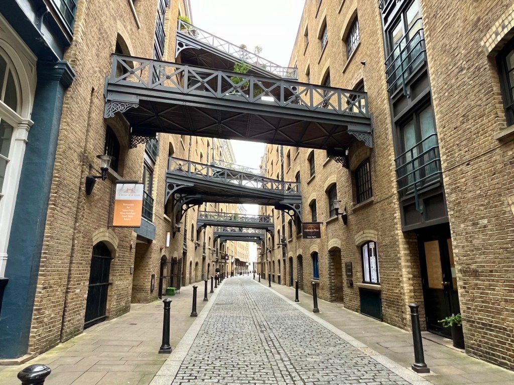
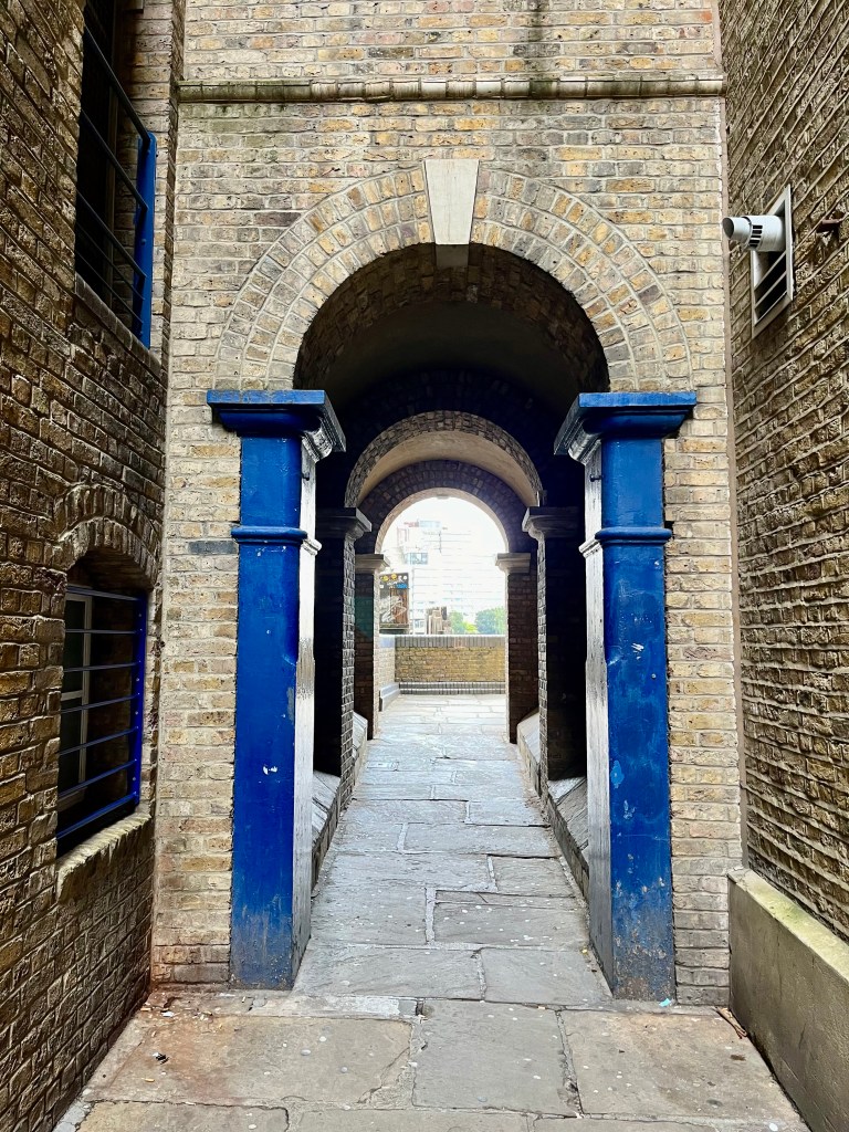
Passageway from Shad Thames to Butler’s Wharf
Opposite Cardamom Building there is a passageway that will take you back to the river and Butler’s Wharf. Shad Thames documents show that a grain trader by the name of Mr Butler rented wharehouses from the Thomas family in 1794, hence the name ‘Butler’s Wharf.’ Today the existing Butler’s Wharf has a public walkway which forms part of the Thames Path with excellent views of Tower Bridge upstream, St Katharine Docks directly opposite, and views of Rotherhithe and Canary Wharf downstream.
You’ll see Butler’s Wharf Pier as you walk towards New Concordia Wharf. Butler’s Wharf Pier is home to a fleet of private chartered boats owned, along with the pier itself, by the Livett family who have been working the Thames since 1710. The current director of the pier is Chris Livett, a seventh generation Thames Waterman and Waterman to King Charles III, having previously served in this capacity for the late Queen Elizabeth II.
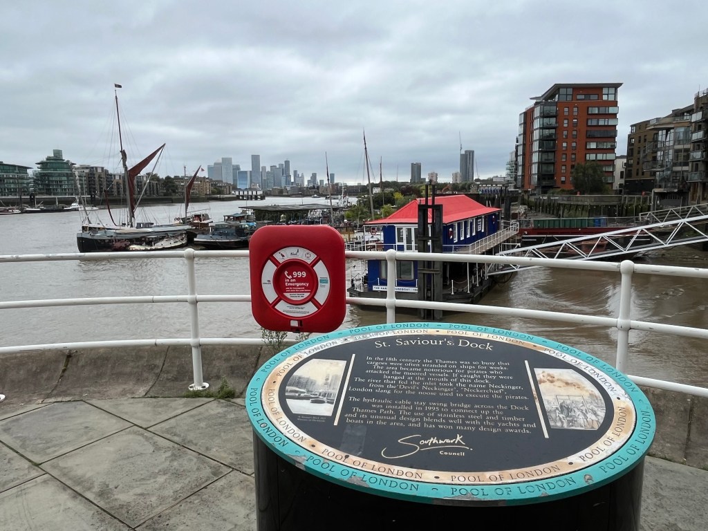
St Saviour’s Dock
I always like to stop and take in the view at St Saviour’s Dock. To the right of my photo you’ll see an inlet which is where the River Neckinger, one of London’s subterranean rivers that rises south of Southwark, flows into the Thames. In the 18th century the Thames was so busy bringing in goods from all round the globe that cargoes were often stranded in the river for weeks on end. Indeed it’s been said you could walk across the Thames from south to north and back again by jumping from one vessel to another. The area became one of many in the Pool of London that was notorious for theft as pirates attacked the moored vessels to steal the goods.
This was one of the main reasons for the creation of the first proper police force in London, the Thames River Police, organised in 1798 by Scottish magistrate Patrick Colquhoun and master mariner John Harriott. Initially funded by merchants from the West India Company who were losing large amounts of cargo to theft and looting, the river police brought much needed law and order to the crime-ridden Thames. Eventually absorbed into London’s Metropolitan Police in 1839 after which they became known as Thames Division. They continue to exist today as the Marine Policing Unit (MPU) and are based at Wapping.
If pirates were caught looting vessels they would be hanged at the mouth of St Saviour’s Dock. The very name ‘Neckinger’, the underground river which reaches the Thames in this spot, is thought to be London slang for ‘Devil’s Neckerchief’, ie a reference to the noose used to execute pirates. I’ve walked this path on foggy winter days when there’s an eerie half-light and you can hear the creak of ancient timber from the wharves, wind whistling through the hydraulic cable of the stay swing bridge (installed in 1995 to connect the Thames Path.) It’s not too far-fetched to think you’ve stepped back into a very dark time when the bodies of criminals were left hanging from gibbets here.
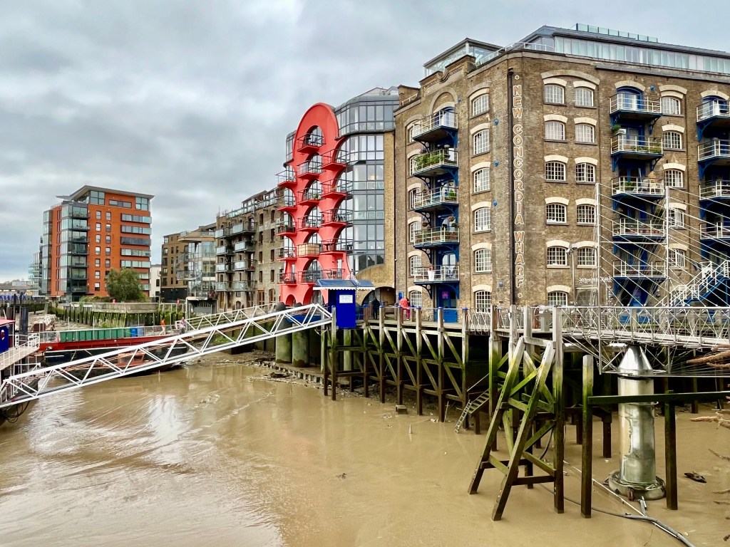
St Saviour’s Dock, view across the swing bridge to New Concordia Wharf
View of old wharehouses behind New Concordia Wharf, now converted to offices and apartments
Just before you cross the swing bridge approaching New Concordia Wharf, you’ll see to your right what remains of the exteriors of Wheat Wharf, The Clove Building, Tea Trade Wharf, Saffron Wharf, Anise and Coriander Court Buildings – remnants of the Victorian spice warehouses, although this site also housed two corn-drying kilns.
Charles Dickens set ‘Oliver Twist’ in the area of Shad Thames and looking back at old photos you can see why. Once notorious for poverty, though the warehouse and ship owners made large fortunes from the import of goods stored here, it would have been dark, dirty, noisy and dangerous for local people, criminals lurking in the shadows. Bill Sikes meets a violent death in the mud of St Saviour’s Dock while Fagin’s Den was located in one of the Shad Thames warehouses.
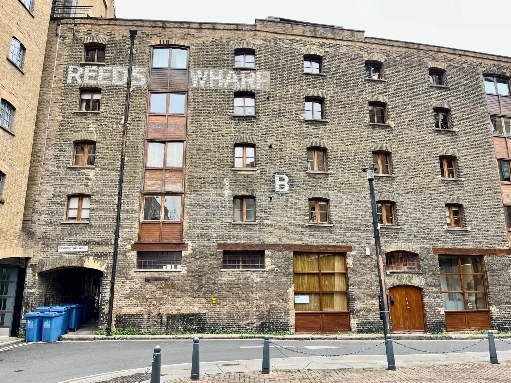
Passageway to Reeds Wharf and Bermondsey Wall West
Continuing along the Thames Path, a striking red-walled passageway takes you briefly away from the river and into a courtyard that belonged to Reeds Wharf, a Grade II listed 19th century warehouse. There’s been a warehouse on this site since the 18th century but the current building dates from the 19th and was a granary once belonging to H. Reed, mainly handling grain from North America.
Reeds Wharf, a former Granary
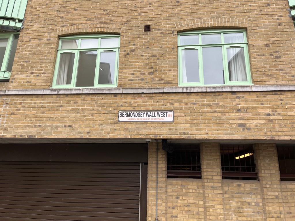
Bermondsey Wall West, part of the Thames Path
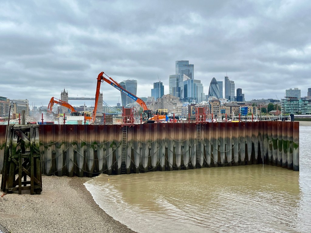
Then continue along Bermondsey Wall West following the well signposted Thames Path route which will bring you back to the river at Fountain Green Square, just past the location of the new super sewer at Chambers Wharf. This is Tideway’s main drive site where tunnelling first began in the Thames, one of the busiest and most important locations of the project. The work is very much ongoing here and this summer has seen Tideway beginning to remove the cofferdam, the temporary area of land built out into the river so that structures could be built below ground. The new super sewer will mean that instead of flowing into the river, almost all sewage overflows in the centre of London will be stored in the tunnel until it can be safely processed. The super sewer is expected to be fully operational in 2025, and not a moment too soon.
Tideway working at Chambers Wharf
From this point at Chambers Wharf it’s now possible to complete the short walk down to Rotherhithe, past Cherry Garden pier, and the end of this part of the Thames Path. There are quite a few points of interest along the remainder of this route.
View from Chambers Wharf downstream to Cherry Garden Pier, Bermondsey to Rotherhithe
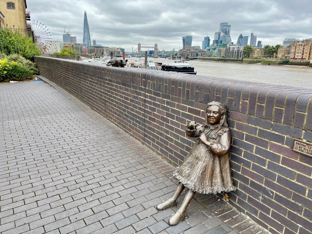
Bronze statue of Joyce Salter and her cat
Tribute to the Salter Family, Bermondsey
One of my favourite parts of this walk as Bermondsey merges into Rotherhithe is the group of riverside bronze statues in tribute to the Salter family – Ada, Alfred, their daughter Joyce and her cat. I’m not a fan of statues in general but I love these and, although tinged with sadness, they somehow always manage to bring a smile to my face. A contradiction, I know, but the statue of Joyce in particular is so full of life.
Ada and Alfred Salter transformed the lives of people in crime and disease-ridden Bermondsey, becoming much loved figures in their community. Alfred was a brilliant doctor with a social conscience who had trained at Guy’s Hospital and moved to Bermondsey at the beginning of the 20th century to work in this deprived area. He didn’t charge the patients he treated, promoting the idea of free health care well before the NHS formally did when it came into existence in 1948. Ada, a social worker, opened clubs which transformed the lives of Bermondsey’s toughest working girls and gave them hope along with a chance of a better future. Ada met Alfred in Bermondsey and they married in 1900, both joined the Independent Labour Party and devoted the rest of their lives to the poor of Bermondsey and Rotherhithe. Ada later became the first Labour woman councillor, eventually Mayor, in London. Alfred was elected MP for Bermondsey in 1922.
The lives of Ada and Alfred Salter were marred by tragedy in 1910 when Joyce, their only child, died of scarlet fever at the age of 8. A highly contagious illness that mostly affects children, today it’s easily treated with antibiotics. At the beginning of the 20th century however, there was no such medication, and in poverty stricken areas of large cities the disease spread quickly. The Salters never recovered from Joyce’s death and threw themselves into work.
Sculptor Diane Gorvin has called these beautifully forged statues ‘Dr Salter’s Daydream’. An elderly Alfred Salter sits by the river imagining his beloved wife Ada, much loved daughter Joyce with her cat, as they once were in happier days.
King Edward III’s Manor House, Rotherhithe
Just to the side of the tribute to the Salter family are the remains of King Edward III’s manor house. Edward III (Plantagenet) ruled from 1327-1377, famous for taking England into battle with the French during The Hundred Years’ War and annexing large parts of France for the English crown. He married Philippa of Hainault and they had fourteen children, one of whom is my favourite forgotten medieval teenage princess, Joan of England.
This Royal building, now a scheduled monument, was actually a moated manor house constructed in 1350 when Rotherhithe was a small hamlet set in low-lying marshland. The King would arrive by boat and moor the Royal barge at river steps that then led directly to a gatehouse.
It’s been said that the manor house may have been used as a hunting lodge but this is unlikely as there was no Royal Park nearby unless the hunting involved water fowl, which was perfectly possible. More likely it was used for the king to practice his falconry as there was a clear view of the birds across the flat marshlands and river.
By the 16th century this area had begun to change significantly in appearance with land being reclaimed and the Thames waterfront pushed northwards. A road was built along the new river embankment, eventually becoming what is now Bermondsey Wall. In the 18th century this site became the Rotherhithe Pottery and by the 19th century warehouses had been built on it, the final warehouse demolished in the 1970s. After archaeological excavations in the 1980s the area was restored to the vista we see today.
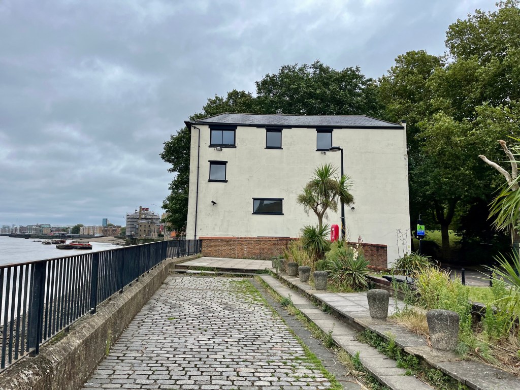
1 Fulford Street, the ‘leaning tower of Rotherhithe.’
As you walk on, keep an eye out for the strange, solitary, cream building known locally as the ‘leaning tower of Rotherhithe’. It has a fascinating history. Recently sold by Savills it was once part of a row of buildings along the river, many of them destroyed or severely damaged by the Blitz.
Previously known as 41 Rotherhithe Street, now renamed 1 Fulford Street, the building was once owned by Victorian barge company Braithwaite and Dean, and used as an office where lightermen (who unloaded goods from flat bottomed barges) pulled up to collect their wages. In 1937-1939 it was home to Winston Churchill’s nephew, Esmond Romilly, and his wife Jessica Mitford. Noel Coward was a frequent visitor to this house as was Princess Margaret with photographer Anthony Armstrong-Jones, who she later married.
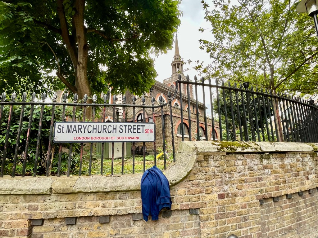
Peeking through the railings at St Mary’s Church, Rotherhithe
Once you’ve reached St Marychurch Street, it’s worth popping in to have a look at the churchyard and church of St Mary’s, if open. The present parish church (full name St Mary the Virgin with All Saints) dates from 1714-1716, though there’s been a church here since the 12th century. It has some very well known memorials incuding one marking the final resting place of Christopher Jones, captain of The Mayflower, which took the Pilgrim Fathers to America in 1620.
It is also the burial place of Prince Lee Boo of Palau, a Pacific Island Prince, and of Vice Admiral Sir Thomas Teddeman. There’s a lot of useful information about St Mary’s on their church website, click on the link below to learn more:
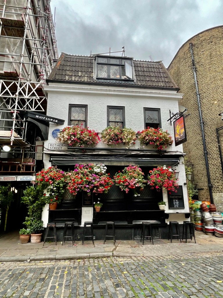
It usually takes me approximately an hour to walk to this point (avoiding the temptation to nip down to the foreshore to mudlark via whichever river steps I happen to be passing en route), though perhaps an hour and a half if strolling slowly and stopping to take photos and gaze out over the river. If you’re well and truly flagging by now, directly opposite the church is the famous Mayflower pub where you can stop for refreshment and then carry on to the Brunel Museum. Or terminate your walk here and make you way home via Rotherhithe Station. It’s your choice entirely and you can always come back another day.
The Mayflower’s history as a pub is deeply and predictably rooted in its location, an area rich in maritime history and trade. Goods would have been unloaded from the nearby wharves and lightermen, watermen and sailors from all around the world have caroused in the pubs and taverns here ever since the 17th century. Rotherhithe was also a busy centre for ship building and ship breaking.
The current building is not the original one from the 16th century and known as the Shippe Inn, later rebuilt and renamed The Spread-Eagle. War damage during the Blitz resulted in a major refurbishment in 1957, which will come as a shock to some readers, because it was only then that it was renamed The Mayflower. The architect responsible decided to recreate a 17th century interior which makes The Mayflower look much older than it really is. But a good story never dies and the pub still has strong connections with American visitors who can sign a ‘Descendants Book’, if they can prove their ancestors sailed from here on The Mayflower ship in 1620.
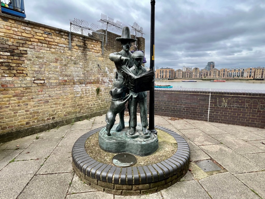
Cumberland Wharf, the approximate site where The Mayflower set sail for America in 1620
If the history of The Mayflower is of personal or historical interest to you, before leaving the area take a left turn as you exit The Mayflower pub and stroll for a few minutes along the Thames Path to Cumberland Wharf. This is the approximate site where the Pilgrim Fathers set sail for America (via Southampton and Plymouth to pick up supplies.) There is a bronze statue marking this event and its place in history.
Charles Hay & Son, 135 Rotherhithe Street
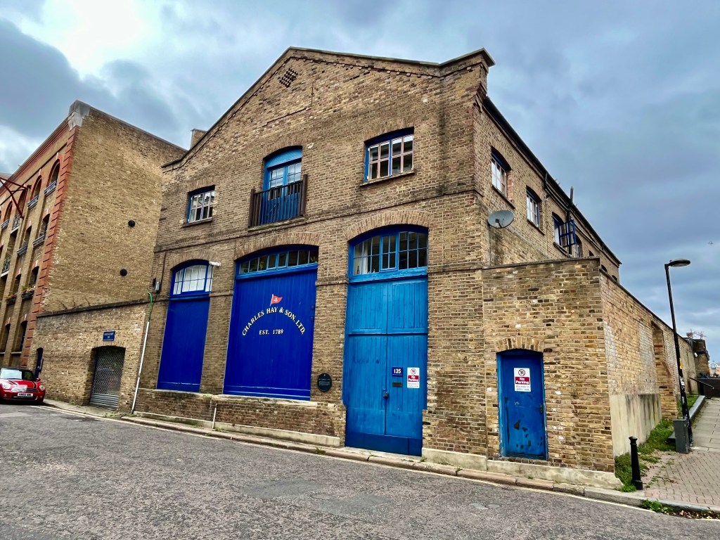
En route to the site of the departure of The Mayflower ship you’ll pass both the Brunel Museum and the sensitively restored building belonging to Charles Hay & Son, located at 135 Rotherhithe Street, who were successful barge and lighter builders. The striking royal blue paint of the doors and windows pops out from the brickwork and gives a real flavour of what this area must have once looked like.
The Brunel Museum, Railway Avenue
Last but not least, the Brunel Museum in Railway Avenue is a fine small museum well worth visiting and of manageable size even if your energy has drained away by now. Run by volunteers, it tells the story of one of the world’s greatest engineering dynasties, French born Sir Marc Isambard Brunel and his son Sir Isambard Kingdom Brunel (named after his English mother Sophia Kingdom.) Check the museum’s website for opening times.
Today the Thames is both recognisable in parts, unrecognisable in others. The London Docklands Development Corporation, set up in 1981 by Margaret Thatcher’s Environment Secretary, Michael Heseltine, who granted permission for massive redevelopment to begin on both sides of the Thames in the mid 1980s, shaped the vista we see today. There was considerable opposition to the initial plans as locals feared buildings being turned into luxury apartments, and old communities pushed to the margins. Much of this came to pass and it’s difficult not to feel sympathy with those whose families had lived here for generations. But even now when walking this stretch of the Thames Path I can still hear old Bermondsey voices in the air, so the spirit and identity of the original residents is very much alive and well in places.
And something tangible still remains of the old city port, the noisy brutal smoky London of commerce and enterprise.
The Thames Path tells the story of London – its trade, its industry, its ever-changing population, its immigration, survival and regeneration. So get walking, and absorb yourself in the history of the greatest city in the world.